Changing Landscapes - Northern Connector
(Mainly) internally funded ARA Priority Research Project
This project uses ARA's airborne remote sensing and in-situ sensing capabilities to monitor areas in Australia (with special emphasis on South Australia) where dramatic changes in the landscape are already or will be occurring in the near future.
One of the areas is the construction of a new 4-lane expressway through areas of mangroves, saline ponds, saline creeks and former market gardens North of Adelaide.
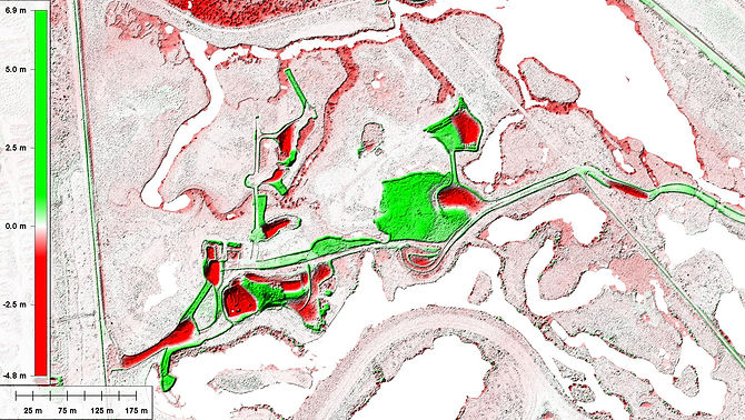
Change analysis showing differences between two LiDAR mapping flights taken on 15 Nov and 21 Dec 2016.
Green means material was added between the two dates,
Red means material was removed.
The blank areas are covered with water. The "red edges" mean that the water level dropped over the month.

15 Nov 2016

21 Dec 2016

The most recent mapping flight was on 4th Apr 2019.
This was the 25th such flight since Dec 2016.
Watch this space....
Changing Landscapes Project
Other areas are currently under consideration and will be announced here once ARA has decided to include them. Additional proposals are also welcome.
ARA is also -in an on-going manner - looking for collaborators in this project who are interested in working with us in many different ways, from adding capabilities to using the airborne data for interpretations which are complementary to ARA's capabilities, or even are prepared to contribute funding to this project, or join forces with ARA to look for Third Party funding from any sources.
Data and results from this project will be available (more or less freely) to the science community and also to other interested parties under terms to be discussed on a case-by-case basis.

