top of page
IMAGE GALLERY
(for best viewing double-click main image)
Images from flights can be viewed in the Flight Gallery
 |  |  |
|---|---|---|
 |  |  |
 |
Mangroves in the mudflats around the Albert River near Burketown, Queensland, as mapped by the ARA/AWI
Tri-Spectral Scanner
 |  |  |
|---|---|---|
 |  |  |
 |  |
Lidar images from Port Hedland, Western Australia and Melbourne, Victoria.
The "Sphinx" is an abandoned brikett factory near Port Hedland (it has been dismantled by now).
 |  |  |
|---|---|---|
 |  |  |
 |
Lidar images from Turtle Reef, Kimberley Coast,
Western Australia
 |  |  |
|---|---|---|
 |  |  |
 |  |
Lidar, hyperspectral and tri-spectral images of Montgomery Reef, Kimberley Coast, Western Australia
 |  |  |
|---|---|---|
 |  |  |
 |  |  |
 |
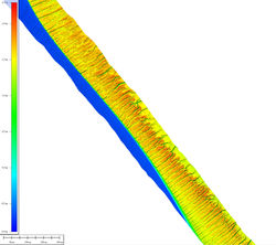
Lidar images of the Salisbury Tip, a collection of trees and trees in water, a plantation with netting and hyperspectral image of Hamelin Pool and Faure Sill in Western Australia.
Note: The image of the coast of Hamelin Pool is 60km long (from bottom to top) and radiometric corrections have not been applied yet.
 |  |  |
|---|---|---|
 |  |  |
 |  |  |
 |  |
Images of the 2017 ARA Desk Top Calendar
at full resolution.
To download, click the main image,
then right-click and select "Save Image".
If you use these images, please reference their source.
Cal hi res 2017
 |  |  |
|---|---|---|
 |  |  |
 |  |  |
 |  |  |
 |  |  |
cal hires 2019
cal hires 2018
LiDAR 3D-Visualisation
We just started to use the potree software to visualise some of our LiDAR data.
Two examples are already available:

Rendered by TERN/AusCover
using data collected by ARA

Rendered by ARA
using data collected by ARA
bottom of page


